Slow traffic means people just add more lanes - off the road - three extra lanes on the road verges in this case! This doesn't tell the full story because cars still overtook on double barrier lines, only to pull over onto the far right verge when there was oncoming traffic. In some places, there were seven lanes of traffic and only one of them legal.

Driving to Polokwane on Sunday morning, I saw something that is commonplace on Limpopo’s roads, in fact it’s the norm. I was overtaken on a blind rise with a double barrier line by a gunmetal VW Golf, registration number 333 BEE L.

Cynical irritation! Does BEE mean you own the roads? Does 333 mean you didn’t quite crack it and with a 777 you’d be driving an Audi, BMW, Merc or Range Rover? Limpopo drivers have killed these brands for me! If I wanted to protect my brand, I’d start qualifying those I sell to because Limpopo drivers are certainly not brand ambassadors.

Driving on, I wondered how long my luck would last. Rural Limpopo has amongst the worst accident statistics anywhere.

I didn’t have to wait long. Further along the non-toll R101, I came across a number of cars pulled over with people crossing the road to look down on the N1 which runs alongside at that point. Obviously an accident and I had to wonder if it was 333 BEE L that had caused it. (I learnt later it was a head-on collision between a petrol tanker and a vehicle, with fatalities.)

A little further on, traffic came to an almost-grinding halt.  Vehicles were being diverted onto the R101 from the N1 and the three traffic cops on point duty would have done the keystone cops proud.  One (an urgent candidate for government’s weight reduction programme for law enforcement officials) was chatting to a driver at the head of the oncoming queue.  The second was trying to get the chatting driver to move on while a third was trying to get another queue to take the gap.  Traffic was now at a standstill!

But it was to get worse… much worse.  By now, the N1 was being diverted where it leaves Polokwane and I experienced my first taste of Limpopo chaos and anarchy.  My route to Polokwane no longer existed.  All traffic lanes in both directions were occupied by vehicles leaving Polokwane.  And that wasn’t enough — they created several additional lanes in the verges.  And these were not only cars and bakkies joining the new lanes, buses filled with passengers were taking the rough-terrain route too.

Those heading to Polokwane were forced to bundu-bash… on the far side of the road signs alongside the edge of the road reserve.

Provincial traffic officers looked on helplessly… these are road manners, Limpopo-style.

There is no patrolling
& policing of moving
violations in Limpopo.

This just demonstrates the Western view of a dysfunctional, lawless Africa. And in this case, it all starts with the Limpopo Traffic Department not doing its job.  You will almost never see provincial cops patrolling for moving violations.  You’ll be stopped frequently for your driver’s licence and you’ll see no end of speed traps, often manned by ten or more officers.

That’s not the solution to solving the traffic carnage in Limpopo.  En route from Johannesburg a week ago on the N1, I noticed a black car approaching from behind very, very fast – way over the speed limit.  It suddenly slowed down as it got alongside me and I noticed the blackened windows and the flashing blue light on the dashboard on the FS-registered E Class black Mercedes.

And there was the speed trap!  Once we passed it, the Mercedes disappeared into the distance in no time, way, way above the speed limit.  One must wonder, was that a standard speed trap location or are government officials and politicians advised of their locations?

Repeatedly in these travels, it’s been traffic violations by provincial officials (especially in Health & Social Welfare vehicles) and politicians that stand out.  They forget that the law applies to them too and they should be setting the example.

How can Limpopo Tourism promote their province when their roads are so dangerous?

What can be done?  The buck stops at the Provincial Traffic Chief.  Is he doing his job?  The carnage on his roads is his responsibility. If he ignores that responsibility, he is party to the homicide that occurs on his roads and should be charged for that crime.

A complaint against the Limpopo Provincial Traffic Department (ref 3400778) has been lodged on the Presidential Hotline.

Posted in Limpopo | Tagged , , , , , | 1 Comment

Simon Anholt and Akela

I attended the Brand Africa Forum in Johannesburg where the keynote speaker was Simon Anholt, someone I’ve wanted to meet for a long time.

He’s been a policy advisor to over 40 governments, author and researcher. He specialises in national identity and reputation, public diplomacy and the public perceptions of nations, cities and regions. Simon developed the concepts of the ‘nation brand’ and ‘place brand’ in the late 1990s.

The first question he asks heads of state when they consult him, is “what is your country’s purpose?”   All lay claim to the “warmth of their people” as one of their greatest attributes.

The interview with him will be published in CapeInfo’s interviews section soon and I hope I will do that remarkable interview justice.

When he heard about Akela, he just had to meet her.  His comment was fascinating — “the dog she looks most like is the Alsation, which isn’t a dog I’m particularly fond of, but she’s much more beautiful.”

Posted in Akela, Travels | Tagged , | Leave a comment

Akela is 12 years old today!  That’s a venerable 84 in human years although, in the wild — where wolves are challenged by the elements, illness, starvation and injury — wolves only live an average of 7 years.  In a domestic environment, they live up to 15 years. We’ve been together since she was five weeks old.

She’s still as active and mischievous as ever, and behaves more like a three-year old dog.  It’s difficult to believe that Kenya the staffie is only six months older.  He’s grey, stiff and deaf.  I’m starting to wonder if wild animals don’t maintain peak fitness until far later in their lives, and then age very suddenly at the end.

Here are some of the most memorable photos of her from the past year.

.
I just love this photo of Akela. She was totally at ease with Rachel and content just being stroked. I love that smile and the glint in her eye.

You can see that she’s shedding here — her hindquarters have lost most of their very fine, soft winter fur. It comes out in chunks which need to be plucked; combing or brushing just doesn’t work. In the wild they run through thickets to pull the old fur out. In Lapland they collect this fur to make their bonnets — it’s the most waterproof fur you can get.

Look at her thin almost dainty legs.  That characteristic sets wolves apart from dogs.  Together with her narrow chest, this helps wolves run faster through very thick snow.

Posted in Akela, Wolves | Tagged , , , | 1 Comment

AS FAR AS WE CAN GO: Akela looks over Zimbabwe. The white specks on the horizon below the mountains are the Zimbabwean town of Beit Bridge.

The N1 starts in Cape Town and ends at Musina near the SA border crossing to Zimbabwe at Beit Bridge — 1,919km later. Is that the longest road in South Africa? If it is, Akela, Kenya and I have driven it together!

Whatever the distance, this feels like another country — harsh, rarely friendly and so last century. I’m starting to understand what Schultz (Mr Tzaneen Country Lodge) — who was very friendly — was trying to explain when he told me about the difference between Limpopo’s tribes. Contrary to what one finds in southern Limpopo, the Venda in the north are outgoing, confident and arguably the most friendly in South Africa.

It takes a trip like this to discover that Archbishop Emeritus Desmond Tutu’s Rainbow Nation doesn’t describe the whole of South Africa.  It does describe the Western Cape where the unique mix of people ensures that domination by one racial or political group is never a given. In northern Limpopo, “rainbow” refers more to the origins of tribes like the Venda, who migrated to the area from Zimbabwe.
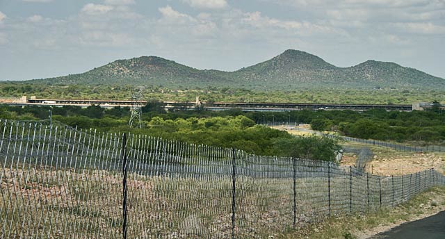
Beit Bridge - the border crossing to Zimbabwe.  The border fence that runs the entire length of SA's northern and eastern borders is in the foreground.  It was built when there was a perceived threat from SA's neighbours - a wide swathe of no-man's land marked by razor wire fences on either side and an electrified fence down the middle.  The dirt road alongside the fence was tarred because mercenaries planted land mines in the dirt road.  The electric fence was switched off post-1994 at the insistence of human rights groups.  The razor wire fence is dotted with holes cut into it but Zimbabweans who swarm across on a daily basis.

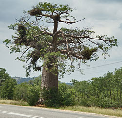
Baobab tree

This particular trip covers just the northern part of Limpopo province — rich in history and home to the Venda. It’s where you find SA’s ancient Kingdoms of Gold: Mapungubwe (SA’s newest World Heritage Site) and Thula Mela (a 13th century global trading centre); Thohoyandou — Venda’s capital, the Limpopo River and the Soutpansberg mountain range.  And the famous Baobab trees.

Driving north along the N1 from Polokwane, the next major town is Louis Trichardt 140km away.  Getting out of Polokwane is the biggest challenge with poor road signs or road signs that lead you nowhere.

Long, crisp vistas and views towards the horizon are rare in Limpopo because of ever-present haze, but through that haze the appearance of the massive Soutpansberg mountain range breaks the monotony of the plains and rocky outcrops.  Turning east at Louis Trichardt towards Thohoyandou only 70km away starts one of the biggest surprises of this trip.  Climbing into the foothills of the Soutpansberg, the vegetation and scenery changes dramatically.

The road to Thohoyandou runs through intensively-cultivated, wealthy farmland.  During the apartheid-era Venda homeland, these farms lay outside the homeland borders and have always been white owned.  This seems to be a recurring situation — black farmers rarely practice and maintain intensive agriculture and land redistribution so often leads to the failure of agiculture, as one has seen in Zimbabwe.  Can land redistribution continue without equal, or even greater, attention to ensure that agicultural production continues and grows even further?
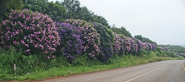
Simply stunning - hedges of alternating pink and purple flowers line the road.

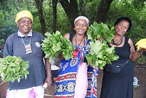
Roadside sellers - dead sheep!

Notwithstanding the organised agriculture after leaving Louis Trichardt, I’ve never experienced the vibrancy and feeling of authentic Africa as much as while driving the road to Thohoyadou.

I came across a group of women with three piles of “green leaves” in front of them. I stopped to ask what it was. The one pile was “Dead Sheep — good for gout and high blood pressure.”  The second pile was leaves from a Cabbage Tree and they didn’t know the translation for the third.  I bought and brewed some “Dead Sheep”… it tasted vile and I don’t think it did me any good… or harm.
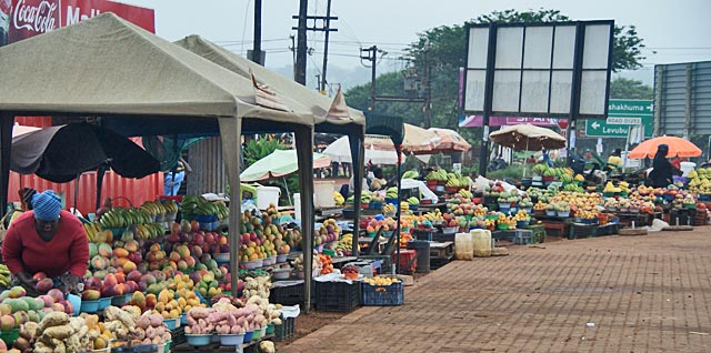
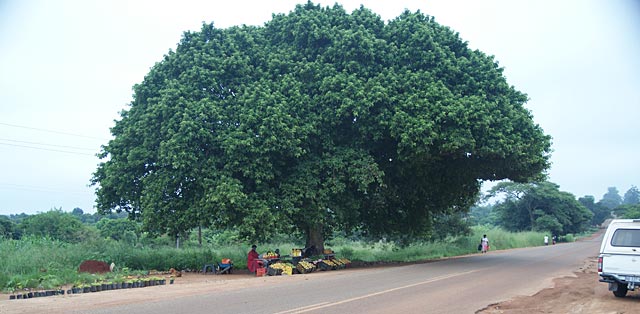
Fresh produce stalls in one of the villages en route to Thohoyandou

After driving hundreds of kilometres without a single roadside farmstall, the road to Thohoyandou was a pleasure dotted with fruit sellers providing perfect photo opportunities.

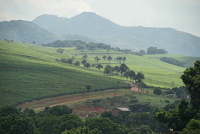
Tea plantations abut the town of Thohoyandou, with the Soutpansberg in the background.

[mappress]

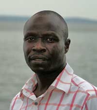
ALFRED MUNYAI: When I got out the car at my destination, a passerby greeted me and asked where I was heading. I told him I had a meeting at the municipality and he offered to help me find the person I was to see. We chatted a while and he said he'd gladly show me around Thohoyandou after my meeting. And so I gained a very good insight into Thohoyandou later in the day. Thank you, Alfred! He seems quite an entrepreneur and is looking for developers who want to invest there.

Thohoyandou is a typical large town that demonstrates the usual bad land-use planning and African chaos — judged by Western standards. But it works better than most and has good formal shopping.

I also felt very safe there — taking long walks till way after sunset and again long before sunrise.  I enjoyed the vitality of street activities and the whimsy of some street traders.
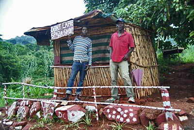
Don't Care Spaza Shop

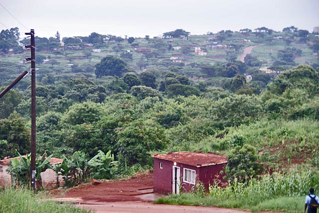
Suburban Thohoyandou - there is a huge difference between traditional Western and African cities and towns. As living expectations in African towns rise, one must wonder how sustainable the traditional low densities can be.

When ?? learnt I was interested in visiting Thohoyandou, he called me and it was his enthusiasm that ensured my visit did take place.

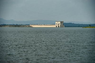
Nandoni Dam on the outskirts of Thohoyandou - A popular resort and base for the community fishing industry.

It must have benefited from its status as the capital of the Venda homeland during the apartheid era — which defied its Pretoria paymasters on occasion — through investment intended to make the homeland system work, but more importantly the skills and confidence as a regional centre.  As a homeland capital, it did get a university and a casino.

If the fame of the Zulu nation stems from its prowess as warriors, the Venda are less well known but have a far longer heritage which started with the Mapungubwe kingdom in the 9th century.  King Shiriyadenga was the first king of Venda and Mapungubwe.  The sacred city of Thula Mela (Place of Birth), not far from Thohoyandou near the confluence of the Limpopo and Levubu Rivers in Kruger National Park, dates back to the 13th century.

It was on one of major trade routes of that time — Islamic traders on the east coast of Africa were the conduit between the interior of Africa and Asia and the Middle East.

Thula Mela was never discovered and ransacked by colonists, and is the only known site in the region that was untouched until archeologists started work.

One can’t help wondering why South Africa, under Thabo Mbeki, invested so heavily in antiquities at Timbuktu when there are so many stories within South Africa awaiting to be uncovered and told.

The pride and confidence of the Venda people does stand out, making them much easier to engage in conversation.

Just to the west of Thohoyandou lies the Thathe Vondo Holy Forest, a beautiful indigenous forest that incorporates the sacred burial ground of the chiefs of the Thathe clan, while the scenic Guvhukuvhu Pool is believed to be the home of water spirits that foster good relations with the ancestral spirits.

No ordinary VhaVhenda people may walk in this sacred forest and, as a visitor, one may not leave the dirt track going through the forest. Two mythical creatures keep guard — the white lion (the spirit of Nethathe, an important chief) and the thunder & lighting bird called Ndadzi, which according to myth flies on the wings of thunder.

North of the Holy Forest lies Lake Fundudzi, one of the best-known sacred places. In the Mutale River, as legend has it, a giant python god of fertility dwells that demands the sacrifice of a maiden each year. Lake Fundudzi is surrounded by mountains and special permission has to be obtained to visit this sacred Lake. No-one washes or swims in this lake.

This annual sacrifice became an integral part of Venda life, together with the remarkable ceremony known as the Domba Dance which has become part of the initiation rites of young women. The dance, also known as Python dance, is performed by rows of girls imitating movements of a python. Both the lake and the Domba Dance may only be viewed by obtaining permission from local authorities.

I didn’t get to visit these areas because I was advised that the roads were in a very poor state.

I did get to visit the Phiphidi Falls, another sacred site closer to Thohoyandou.  A complex collection of laws and rituals, some of which are closely guarded by clan elders, govern clan practice and behavior at Phiphidi; the site has traditionally been off-limits to all but the Ramunangi. Traditional belief holds that the waterfall and pool are inhabited by ancestral water spirits who require offerings of grain and beer, which are made on LanwaDzongolo. These powerful spirits receive prayers from the people for rain, health, agricultural abundance and community peace. Traditionally, these offerings were made throughout the year, with one primary and complicated annual rite that lasted many days.
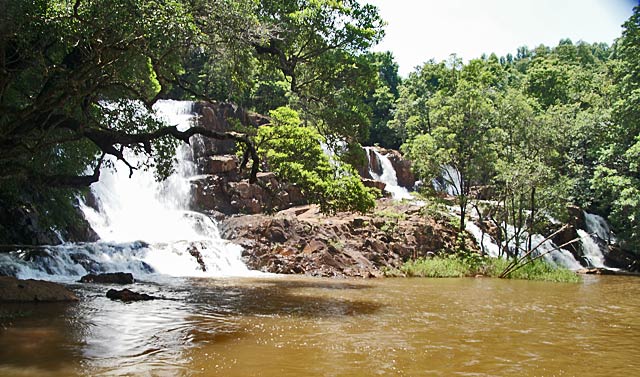
The sacred Phiphidi Falls

The vhaVenda clans are among the SA’s most traditional, observing rituals and practices passed down from their ancestors. Among these clans, the Ramunangi are acknowledged as the traditional custodians of Phiphidi Waterfall, a small cascade that is central to the clan’s relationship with ancestral spirits. This custodial responsibility, however, is not legally recognized, which has limited the Ramunangi’s ability to protect their sacred site from tourism development. A rock above the waterfall — one of the site’s most holy areas — was recently destroyed as part of a road-building project, and for years, the Ramunangi have been denied full access to the site to perform their rituals and custodial duties.
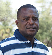
ALBERT DZEBU: Local economic development & tourism @ Musina Municipality.

The next stop was Musina, and for that one has to go over the Soutpansberg at Wyllie’s Poort. The highest peak in the mountain range is Lajuma — 1,747m.
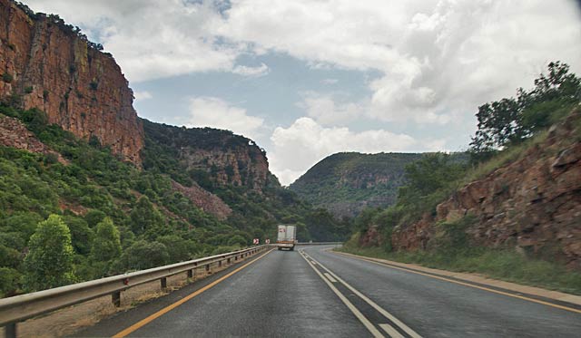
Driving down the northern descent of the Soutpansberg.

The first white person to reach and name the mountain was Coenraad de Buys, a colonist who fled from Graaff Reinet after a failed rebellion in 1795. He settled near the mountain in 1820 and was the patriarch of a half-caste clan, the “Buysvolk” or Buys People, who are still to be found at Buysdorp.

Driving over the Soutpansberg one just has to wonder how it must have been crossed by ox wagon. The vegetation on the southern side is almost imprenetrable it’s so thick. The road curves (with no laybyes for photo opportunities) below steep cliffs. It is a stunningly beautiful drive!

It’s only 92km from Louis Trichardt to Musina, but when you cross the Soutpansberg you enter a different world: one dotted with those weird and outlandish Baobab trees.
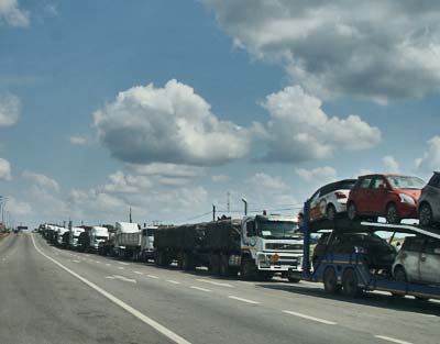
Trucks and more trucks for kilometres and kilometres waiting to cross the border post at Beit Bridge.

Musina is a mining town — copper, iron ore, coal, magnetite, graphite, asbestos, diamonds and semi-precious stones — but its recent claim to fame is as one the busiest road in Africa and one of the busiest in the world — due to black market importers from Zimbabwe, a situation that will hopefully diminish.

The drive along the border fence was illuminating. Apart from the holes in the border fences, we drove past a military camp. Groups of Zimbabwean refugees were being detained for repatriation, but what really caught my eye were the army tents — with air conditioning units sticking out of the sides of the tents. The SA Army is not what it used to be!

The crisis in Zimbabwe did bring some prosperity to Musina but that, like the mines, won’t last forever. Increased regional tourism could help to fill the gap and Albert Dzebu is hoping that Musina can get a deal out of Anglo American similar to the one Phalaborwa received from Rio Rinto. (See Mining can add value.)  I hope so because I am getting the feeling that most mining companies don’t contribute as much to communities as they claim.

It’s almost incomprehensible that two towns — Thohoyandou and Musina — only about 100km apart as the crow flies, can be so different.  Yes, micro-climates and vegetation play a role, but I’m starting to get the feeling that mining towns have the guts sucked out of them by the companies that “own” them.  Mining stifles community entrepreneurship and creativity — the mines are all that count.  But that’s for another blog post.

I didn’t get to Mapungubwe, only 80km to the west and SA’s newest World Heritage Site.  SANParks never answered my email asking for permission to visit with a wolf.

Why is Mapungubwe special?  It abuts the Limpopo River where the borders of South Africa, Botswana and Zimbabwe meet.  It is the site of an ancient civilisation that predates the great Zimbabwe Ruins.
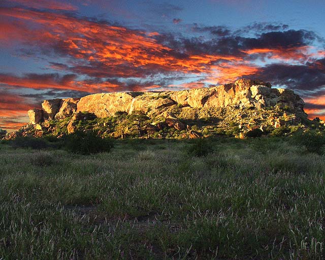
Mapungubwe Hill, seat of the Mapungubwe Kingdom (1075-1220). Mapungubwe means "place where jackals eat", derived from phunguwe  (Venda for jackal), as the hill was littered with human bones which attracted these scavengers.[8]  It is a sandstone hill, with vertical cliffs about 30 metres high and a plateaued top approximately 300m in length. There was a natural amphitheatre  at the bottom of Mapungubwe Hill where the royal court was likely held. However, the king actually lived inside a stone enclosure on a hill above the court.

This is an area I’m sure I will visit again.
Posted in Limpopo, Places, Travels | Tagged , , , , , , , , | Leave a comment

It takes a rather unusual person who — to support the launch of a friend’s new book — will undertake an epic 31-day walk from Inhambe in Mozambique to Schoemansdal near Louis Trichardt in the foothills of the Soutpansberg mountains.

And that’s what Louis Changuion did in 2002. He retraced the 900km journey of 19th century Pastor Montagne, a Roman Catholic priest, on foot, wearing a cassock. (And Montagne certainly did not do it all on foot. He would have been carried in a hammock by porters for much of the way.)

Schoemansdal was the main centre of the Boers in the north and they had contacted the Portuguese seeking a seaport they could use. Pastor Montagne in Inhambe, then Mozambique’s capital, volunteered to to visit Schoemansdal to see what the Boers needed. Apparently, he’d had an affair which resulted in a child, and he welcomed the chance for an extended absence from Inhambe.

It wasn’t long after that Schoemansdal was evacuated on instructions from Pretoria. The war between Boer and Venda was not going well and, since the safety of Boers in Schoemansdal was risky, Pietersburg (Polokwane) was established as the main town for the north.

But Changuion, then professor of history at the University of the North (now University of Limpopo) and a very fit and keen hiker, had prepared a schedule and stuck to it. He arrived in Schoemansdal in August 2002 on the day the book was launched.

[mappress]

Changuion moved to Haenertsburg in 1971 when he accepted a teaching post at the University of the North. He didn’t like Pietersburg and… well, who wouldn’t want to live in nearby Haenertsburg?

One of the attractions of Haenertsburg and Magoebaskloof was the opportunities for hiking and it was this that led to Changuion’s first book — on hikes — which, he says, is the first hiking book published in South Africa.  One of the hiking trails around Haenertsburg has been named the Louis Changuion Trail and starts at the village hall.

And so he started celebrating the area that had become his new home.  His literary output continued with works such as Silence of the Guns : the history of the Long Toms of the Anglo-Boer War; Uncle Sam, Oom Paul en John Bull : Amerika en die Anglo-Boereoorlog; and Pietersburg 1886 – 1986.

His imprint on Haenertsburg is the Long Tom Monument — the open-air museum in the village which commemorates all the wars which involved local inhabitants — the Makgoba War, the Anglo-Boer War, the World Wars and the Border Wars.

He also influenced the aesthetics and character of The Pennefather complex in the centre of the village — self-catering accommodation and a few shops — which celebrate Haenertsburg’s gold-prospecting past.

It’s largely because of Changuion that Haenertsburg is arguably the only town in the whole of Limpopo that really celebrates its heritage.

Posted in Limpopo, People, Places, Route 71 | Tagged , , , | Leave a comment

Back to Route 71 that links Limpopo’s capital, Polokwane, to Phalaborwa, right on the border of the Kruger National Park — a distance of ±300km.  I explored Magoesbaskloof briefly when I stayed at Bramasole Guest House and met with a remarkable lady.

This time I would explore further, using Haenertsburg as a base.  On our first drive along the R71, I was told to stop in at the Iron Crown Pub & Grill, so I already knew that this tiny village of fewer than 200 houses has something going for it.

Magoesbakloof is known as the Land of the Silver Mist.  This photograph gives some indication of why… mountains, ravines & valleys, forests, lakes and mists.

Stanford Lake in Magoesbaskloof

I was being hosted by Linda Miller who was looking after The Pennefather, which I had noticed during my drive up the main street on my first visit to the village.  It’s a complex of two trading posts and six self-catering cottages that celebrate Haenertsburg’s historical mining era.

The cottages draw their names on Haenertsburg’s history — Karl Mauch, Ferdinand Haenert, Doel Zeederberg, Rider Haggard, Long Tom and Prester John — and the trading posts from the long-gone mining companies.  The building style is as it was then — Victorian using corrugated iron for walls and roofing — but certainly far better appointed than any miner’s abode!

The cottages do look tiny from the outside (I was really puzzled by them on my first fleeting visit) but they are remarkably spacious and comfortable.  Linda also manages Magoebaskloof Tourism and is very knowledgeable about the area.

Spacious, comfortable and quaint self-catering cottages at The Pennefather

It may be a village, but Haenertsburg and Magoesbaskloof  surrounding it is one of Limpopo’s gems.  I’d rate it as one of South Africa’s finest destinations and as strong a destination as any I know in the Western Cape — its strength stems from a collective effort rather than single lodges, etc,  that are the norm in Limpopo.

You can easily spend a week here and find you haven’t done all you set out to do.  The area clearly caters for tourists, and many of the locals are tourists who decided to make it their home.  It’s these successful city businesspeople who have turned sleepy hollows into vibrant communities in so many small towns throughout South Africa.

Convivial host and SA's first streaker

Magoesbaskloof has no shortage of eating places.  I mentioned the Iron Crown Pub & Grill in the village in an earlier post.  It is a destination in its own right.  But the Pot & Plow out of town surprised me too.  A bustling pub & pizzeria that was full of young people the night I was there. I returned the following day to find it also has a popular outdoor area.

That’s when I met Gary Barnes — Pot & Plow’s convivial publican — and Gavin Stanford, who’s claim to fame is that he was South Africa’s first streaker during a boring cricket match at The Wanderers in the 1970s.

I was also invited to join Stuart & Linda Miller for supper at the Red Plate in Haenertsburg.  Just after we all ordered, there was a power failure!  Not unusual I was told.  And Red Plate came up with an alternative menu they could deliver on… and it was very good.

When you explore the area, don’t just follow the R71 because the R528 (which is an alternative route to Tzaneen) is just as scenic and you’ll need to take that to see the Ebenezer Dam and Woodbush Forest Reserve or to go on a canopy tour.

Roads to Cheerio Gardens and Wegraakbosch Organic Cheese Farm lead off the R71.

Two sights in the village shouldn’t be missed. There’s the Long Tom Monument — an the open-air museum in the village. The museum commemorates all the wars which involved local inhabitants and includes the Makgoba War, the Anglo Boer War, and the Border Wars.

The other is the ultimate resting place — the Haenertsburg Cemetery!

Resting place with a view: Haenertsburg cemetery

There is more on Haenertsburg & Magoebaskloof in our destination pages.

Posted in Accommodation, Limpopo, Places, Route 71 | Tagged , , , , , , , | Leave a comment

If it’s Akela who’s best remembered during our travels, it’s Kenya the Staffie who makes the most friends.  He is getting old, white-faced and stiff, and turns 12 in February 2010.  Here Kenya’s even being necked by Bees the cat.

Kenya being necked by Bees

Kenya being necked by Bees

Posted in Travels | Tagged | Leave a comment